

Key Facts:
Distance – 50 ish miles
Finishing time – 13:59:52
Finishing place – 43 of 102 on the Apocalypse 50
Vertical gain – approx 10,000ft
Strava data – https://www.strava.com/activities/576189193/embed/39d77b103d4a96f1e4dce9b26eb7f3dbb9e35c77
Results – http://beyondmarathon.com/apocalypse-100/results2016/
This was no ordinary trip up north for me for an ultra. I was looking forward to a 50 mile ultra and my wife was coming too and she had a place in the “baby” 25 mile event. Susie’s comment: “I liked it. I didn’t get lost. That was useful. Scenery was pretty. Ups were hard but the downs were nice”.
Richard Weremiuk from Beyond marathon organises the most amazing and blood curdling of events. Usually around Shropshire and the Peak District. So, it was no surprise to read in the extensive participants handbook about the four routes – each named such that you could say “Yes, I’ve already done Famine, so I am going out for some Death now”.
The concept of the race is simple. Four routes. Each varying in distance from around 9 miles to around 14 miles, and each ranging in toughness from tonnes of up to a billion tonnes of up. Each route can be run clockwise or anti-clockwise (and indeed some people did run counter to most of the participants – either because that is the way that they had recce’d the routes in the past, or just because.
We were staying up in a hostel just outside of Church Stretton. There were others there who were here for the walking, but no one for the event itself (though they mentioned a similar walking based event in October which covers 50 miles).

Me and Susie turned up, received our “passports” which had empty stamps for the checkpoint clips, and a space for a bit completion stamp at the end. We then attached our race numbers and discussed which routes we would do first.
I had put the gpx files – thanks to Richard – on both my Eurex 20 (my trusty handheld garmin GPS which has OS maps on) and also my spare Garmin 310XT which I gave to Susie to use to give her some backup on the navigation. There were extensive instructions which looked easy to follow and we both read through the first few paragraphs of the first one – Death – which we planned to do together.
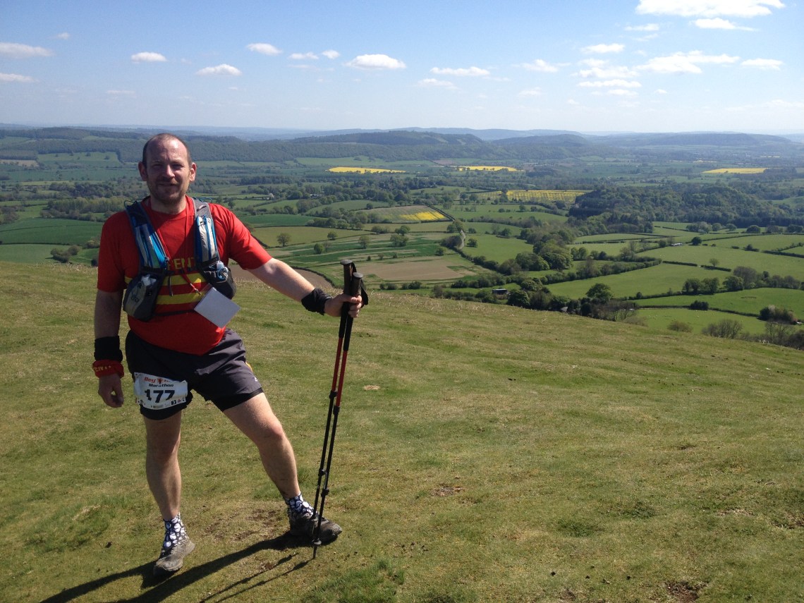
Death – 12.5 miles / 2,400ft ascent / 2:53:56 time.
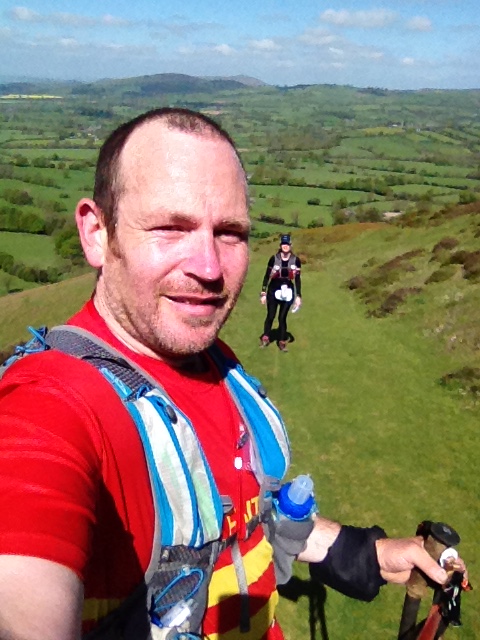
We were a couple of minutes late starting as we finished organising ourselves, then ran through the inflatable gantry start line outside. We immediately started to catch up with the back runners, and as we headed towards Church Stretton, runners started peeling off to the left, and right to start their different loops. It seemed that everyone had different thoughts about how to complete it. Indeed some people would do 2, 3, or the full 4 loops but no one would know this early on in the race.
Me and Susie took things leisurely. I wanted to make sure that Susie was good with the navigation, and so that she could get used to following the instructions and checking on the GPX breadcrumb route. Soon we were heading up, and up, and up….. it was relentless. I had been told by another runner a few weeks earlier, that lots of people run up these hills and then suffer big time later on. So I knew not to worry that it would all be like this and soon it would be easy to run.
Me and Susie were soon skipping along, running on a variety of paths, and finding navigation pretty straightforward. Soon we had a big death march up a huge hill on the Death loop. A few stops here and there, and we were soon at the top.
A bit more running, and we were soon back at HQ. Susie had urged me on ahead so that I could get out as soon as possible on my second loop. Susie was only doing the two loops – she was doing War next.
Famine – 14.5 miles / 2,450ft ascent / 3:43:02 time.
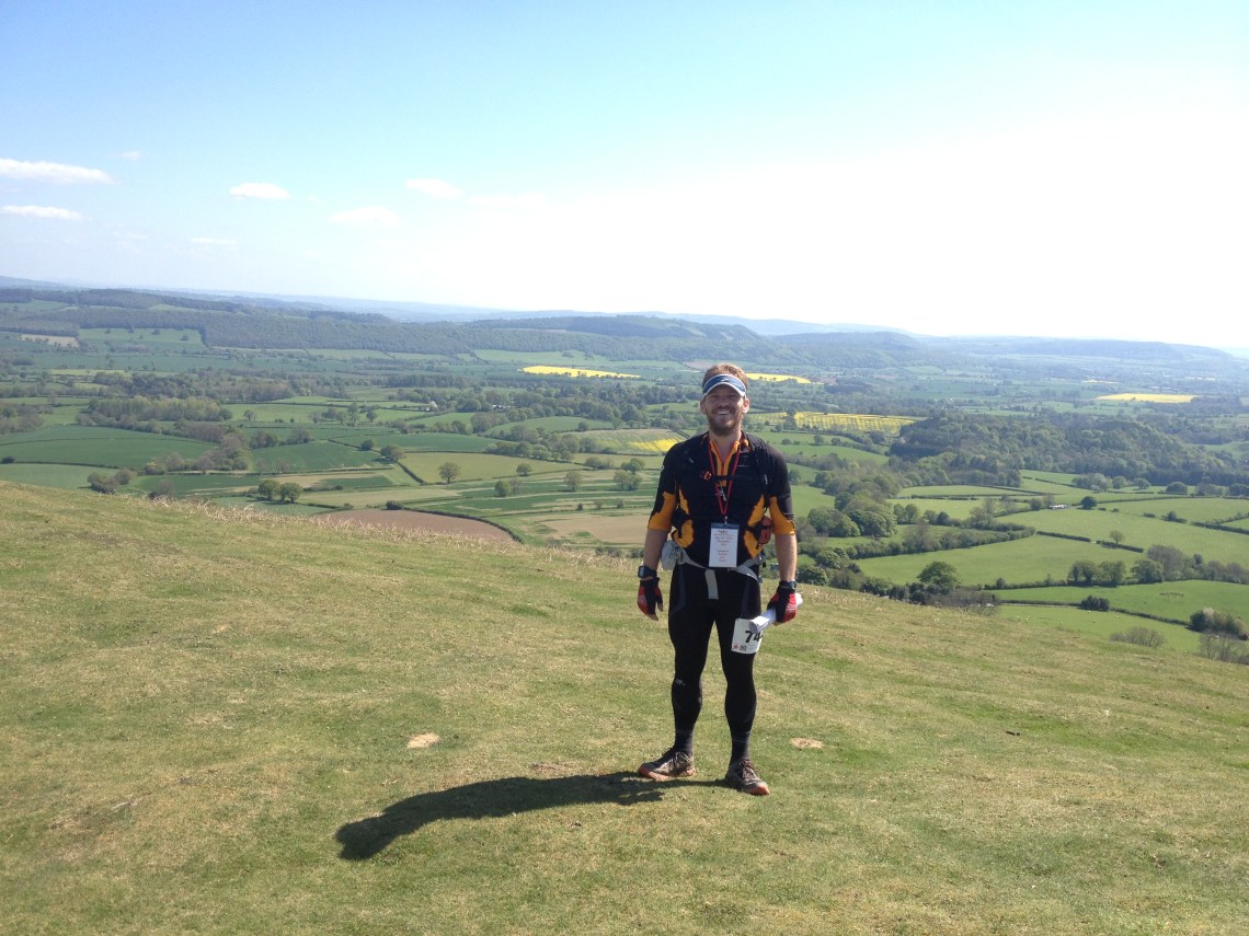
I opted for Famine on the basis that it was the longest route (14 ish miles). I set off on my own, running against some strong looking runners, presumably on their way back from Famine already, and I was swapping my trekking poles (aka cheat sticks) from hand to hand, while holding the instructions, and my etrex. All a bit much for one person, so I put away my etrex – deciding to use it just as back up navigation – and to focus on the instructions because they had the all important Checkpoints marked on them.
I soon came across a chap on an uphill section who was searching for a checkpoint, I reassured him it would be further on, and we continued. Soon we spotted the checkpoint, clipped our passports and then headed down hill and on to a rare tarmac section. It was there that I bumped into a chap called Dave. We ran together – I usually don’t do that – but he was good company and we were running similar speed – and I could see that he was a tough cookie from some initial answers to my questions about his running “CV” (He had done most of the 12 Labours of Hercules last year so I knew he was hard-ass!).
We discussed our plans for the order we planned to do the rest of the routes, and the relative merits and our reasoning. We would both definitely be running this route together, but the remaining two we were planning to do in different orders. I wanted to do the short one next and leave a longer one tip last. He wanted the opposite. I was thinking that since I was planning to leave the mandatory one (for a medal) til last, then it would guarantee that I would complete the 50 miles (because I was harbouring the idea of only doing 3 of 4 routes). It was hot and I think I was starting to suffer from not drinking enough.
Towards the end of the Famine loop, I decided that I would man up and do all of the routes. I found it odd that I was thinking of cutting the event short. We were soon back at HQ, each grabbed more water and food, and headed out together for the next loop.
War – 13.5 miles / 2,600ft ascent / 3:34:59 time.
I somehow lost my instructions which meant that it was all about teamwork with Dave. Him on the instructions, making sure we didn’t miss checkpoints, and me on the GPS making sure we were on track.
We were soon heading up Cardington Valley. This is a National Trust honeypot of a place. There is a tea room and a shop, and a billion people around. We also spotted a couple of runners blasting down the hill and going at amazing pace (we figured that they must be some of the front runners in the event). Dave had mentioned that he planned to stop in the shop and buy some coffee curd. Still not sure what it is, but guess you can put it on bread. Either way, it sounded delicious, but his plan wasn’t to eat it straightaway, but to put it in his bag to take home (it comes in a heavy jar!). While we were in the shop, we took advantage of the ice-lollies on offer and I bought two. A twister and a posh looking Callipo type thing (you know, frozen, coloured water in a cardboard tube). We were soon heading up. I felt really hot with the sun beating down, and I stupidly grabbed some water from a stream, throwing it over my face and in the process washing sweat into my eyes. Not advised!!
This was the easiest route to navigate and we made easy business of it. Most of it was pretty runnable and quite a lot was on tarmac. So, with both of us getting short on water with 3 miles to go, we doubled down, and got back as fast as we could.
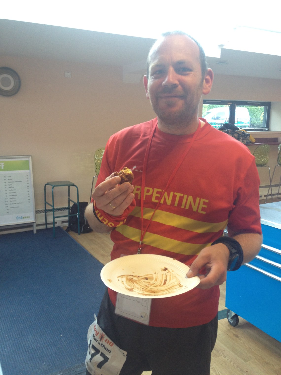
We had a slightly longer break at the HQ. I spotted a bottle of brown sauce at the serving hatch. “I will have whatever goes with that brown sauce”… I said. I was delighted to find the answer was a meat pasty! Soon I was stuffing my way through a meat pasty and several samosas and other bits and pieces. Susie was great, she had finished her two loops and was on hand to fill my bottles with water for the final loop.
Conquest – 9.5 miles / 2,350ft ascent / 3:08:42 time.
It was still light when we headed out, but we had our head torches for later. There was only 9 miles between us and the end but they would be the toughest miles ever – with over 40 miles in our legs already, and a massive amount of ascent still left to do. We bumped into a group who had finished three loops and were already packing up outside. They gave us their best wishes and said we were nuts. We ran against some of the runners already finishing their final loop (presumably – it was hard to judge) and we all exchanged knowing glances and cheers. Soon we were running through a field, and then trail and then the first ascent of the hill. Steep was an understatement. I relied on my poles to get to the top.

The sun was already starting to dip below the horizon, and I knew that we had 15-20 minutes of running before head torches would come out.

We cracked on and ran past a few people tackling the route the opposite way around – including one running with his dog – which was really well behaved (the dog that is!). We stopped briefly to talk to a couple of other runners and took the opportunity to don our jackets and head torches for the final stretch. Up and up we went. The wind had picked up and was blowing us into the side of the hill as we ascended by digging in our toes into the soft earth and grass. At the top we clipped our passports and headed along the ridge, a bit more down, and then back up again to the final crest of the hills and along.
Soon we were picking our way down the final hill, and after a navigation faux pas we climbed over some barbed wire and back onto the route proper. Last checkpoint clipped, and then retracing our steps back to the HQ. We ran the last mile and a half without even a pause. We decided we would push it to get in just under 14 hours for the (51 ish) miles we completed. It was quite exciting to run through the corridors of the school to find ourselves in the hall but with no one to scan us back in…… soon one of the volunteers came along, scanned us and we were finished! Time for food – and some cuddles from Susie.


Top tips and good stuff
- Aid Station – The aid station food is amazing…. the food available is varied, sweets, pasties, chocolate, indian food, and pork pies. The best aid station in the world ever!
- Running with Susie – It was brilliant to do one of the routes with Susie. I had lots of fun and we didn’t argue once about the navigation.
- Other runners – It’s fun to run with others sometimes – like Dave for example – if your pace is matched and if you don’t feel beholden to each other to stick together.
- Sharing the navigation works really well. You get to debate the directions and avoid silly errors (most of the time).
- Order of the routes – Leaving the short route til last was definitely an inspired decision. It would have been a struggle mentally to have to go out for a long route at the end – probably on my own.
- Route instructions – a plastic slip in folder for the route instructions means that your paper doesn’t get wet – and therefore completely useless.
- Photos – There is always time for photos on an ultra!
- Buzzing HQ – The HQ was a hive of activity and war stories about the routes that others had done and had an amazing buzz about it.
- Learning about other races – Because some of the routes are similar to the ones used on 12 labours of Hercules – it was great to get acquainted with the area.
- Bunkhouse – We had the opportunity to check out the bunkhouse in the area. Works really well – and is ideal place to explore the area.
Things that I learned or that I would do differently
- Blister prevention – Do NOT use powered PTFE in your socks (I used a free sample I got with some gear I ordered and used it because I had run out of Body Glide). It meant that my feet slipped inside my socks and bashed the crap out of my toes at the front of my shoes. It did prevent blisters though!
- Water – Take an extra bottle of water if I need to do more than 10 miles in hot weather – one litre is not enough.
- Trail shoes (my Kalenji Kapteren Discover) were absolutely perfect for this race. It wasn’t muddy, and it was only wet in a few places.
- My pack – I have to find out why my Ultimate Direction pack is rubbing on my back.
